")


Bay Waka recently met with Tauranga City Council transport manager Martin Parkes and transport engineering advisor Bruce Robinson in order to learn about how software technology supports TCC decision making to improve efficiency in our city’s transportation system.
Cars, cars everywhere
Did you know that in Tauranga less than 1% of people use public transport and less than 1% of people ride bicycles to get around? This means that at least 98% of people move about in private vehicles. But today, we were in the company of the 1% as both Bruce and Martin describe their personal electric bicycle use to get around and the enjoyment this brings to them.
One long-term goal of the TCC Transport Department is to support more people using the bus network and to make cycling more appealing and safer, thereby encouraging more people out of their cars.
What is traffic modelling?
Back to the important matter at hand. How do we know TCC Transport Department are doing a good job? We still have to wait 12-15 minutes in our vehicle, crawling from the Maungatapu roundabout to 15th Avenue and up to 45 minutes if coming from the other end of Welcome Bay, during a school morning. Why can’t that be fixed? And if it were, wouldn’t that just have a knock-on effect somewhere else?
“At the strategic end of the scale citywide, traffic modelling is like water modelling using pipes and valves,” explains Bruce, “Except in our case it is a two-way pipe-flow with potentially 16 different decisions at every junction (left, right, straight and U-turn per approach). In this case, the “fluid” is human beings who, being different from water, can make snap random decisions to change their minds and direction for any reason.
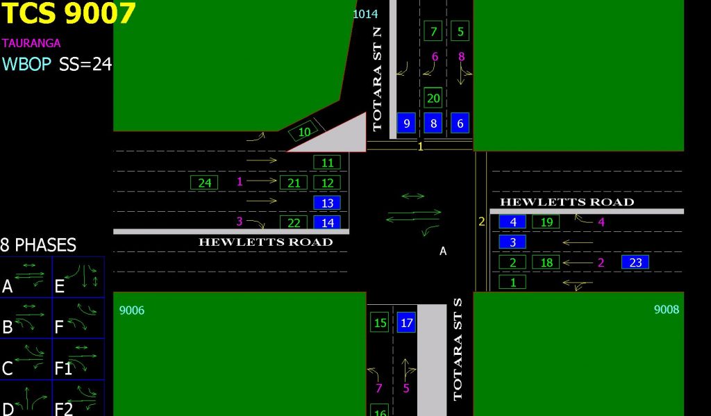
At the other end of the scale, there is real-time modelling and control of individual vehicles, bicycles and pedestrians. Inside the traffic operations centre in the TCC Transport Department. You could be excused for thinking you had stumbled into a NASA control room with the high number of screens tracking moving objects on display.
Software hero SCATS
In the control room, the real-time software used is called SCATS and was originally developed to deliver sophisticated adaptive traffic control functionality to key roads within Sydney (abbreviated from “Sydney Coordinated Adaptive Traffic System” to SCATS). All cities in New Zealand use SCATS today.
SCATS is fed by 100’s of different sensors spread all over the city, and believe it or not is programmed to try and give every vehicle and pedestrian a green light as they move from intersection to intersection. It is a truly an impressive example of how software technology, using multiple in-built algorithims is adding real-time value to our city while we are blissfully unaware of its existence. Without SCATS, you would probably need to double, triple or more, the amount of time it would take to move about in Tauranga by road.

SCATS side-kick Cube Voyager and the trusty Tauranga Transportation Model (TTM)
Another powerful software tool is ‘Cube Voyager’, implemented in the Western Bay of Plenty to model predicted traffic flows referred to as the Tauranga Transportation Model (TTM). This is the “strategic travel demand” software, calibrated every five-years against the NZ Census travel surveys, population and employment locations. The algorithms from consecutive census’, together with future land-use and transport network scenarios provided from SmartGrowth and other sources, help to deliver predictive traffic models for 10, 20, 30 and even 50 years into the future.
The calibrated TTM allows for macro-level monitoring of the projected traffic demand of all the roads between Te Puke and Katikati. This together with the SCATS real-time data identifies priorities for the coming 10-year transport plan met by the average annual transport budget of around $50M.
Upgrades on the way
In 2018, the TTM will receive an exciting upgrade with new additional software taking the TTM from a macroscopic model to a much finer level of detail and which will begin dealing with people and vehicles as bunches or particles, rather than as fluid flows.
At the same time, as we wrapped up our discussion, Bruce threw in the term “back-forecasting”. This is where you take old sensor data to see how accurate the TTM modelling was in the factual reality of hindsight.
Martin said, “with sensor technology we have gone from ‘data-sparse’ to ‘data-rich’ and the models are also getting more sophisticated and more data hungry”.
Pity the IT department of the TCC having to keep these resource-hungry algorithm-intensive applications running at optimal speeds to allow this work to be done in real-time.
In our next conversation with Martin and his team, we’ll go further down the rabbit hole and ask him to explain in more detail about their other software application called SIDRA for road corridors, recently run to determine the new potential traffic design impacts for both Fifteenth Avenue and Greerton (that was recently shared with the public).
Stay tuned...